Surface Intelligence for Subsurface Discovery
Accelerate Discovery with Advanced Remote Sensing
The demand for critical minerals is growing, yet traditional mineral exploration methods are slow, costly, and environmentally intensive. Mining companies need to accelerate discovery while minimizing impact—unlocking new opportunities faster and with greater confidence.
EarthDaily delivers cutting-edge geospatial intelligence, enabling mining companies to revolutionize their exploration workflows. Our innovative data solutions and expert-driven analytics empower geologists to assess targets efficiently, reduce exploration timelines, and extract deeper insights—without the need for complex coding.
With industry-leading technology for modern geologists and exploration teams, reducing risk, optimizing exploration budgets, and identifying deposits faster than ever.
- Analysis-Ready Data – Gain access to the world’s best catalog of multispectral, hyperspectral, geophysics, geochemical, and other data, curated for the exploration geologist.
- Results on Demand – Point and click tools and hyperspeed compute lowers the bar for remote sensing newcomers, and maximized geologist productivity.
- Seamless Data Integration – Combine proprietary datasets with EarthDaily’s vast geospatial catalog.
- Develop Expertise – Leverage the experience of expert remote sensing geologists for guided training and onboarding, upskilling your team.
Find your next big discovery – Schedule a consultation today.
Data Collection & Guidance
Leverage our expertise to select the best satellite imagery and sensor data for your exploration needs. Our team provides guidance on wavelength ranges, resolution, and pre-processing requirements, ensuring your data is optimized for actionable insights.
AI-Enhanced Processing & Analysis
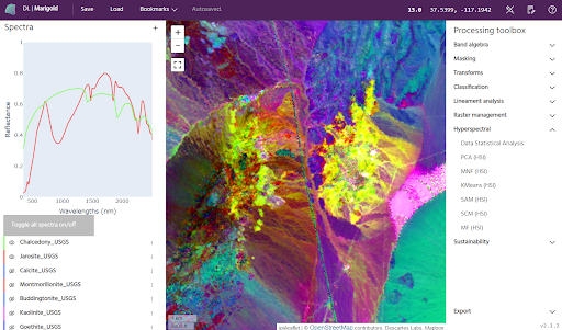
Our automated data pipelines eliminate processing delays, freeing your geologists to focus on interpretation rather than data preparation. With our advanced computing capabilities, exploration teams can analyze more data, test more hypotheses, and refine target areas with unprecedented speed.
Geospatial Intelligence for Targeting & Decision-Making
Accelerate fieldwork planning with deposit-specific insights and spectral interpretations. Our iterative approach ensures that exploration campaigns are continuously optimized for greater accuracy and efficiency.
EarthDaily delivers the most advanced satellite-powered geospatial intelligence to help mining companies discover deposits faster, optimize resources, and minimize environmental impact.
Get started today. Connect with our experts and see how EarthDaily can transform your exploration success.


