Remote Sensing Hardware
Sensors
Sensors are the actual instruments that collect data about the objects they are observing by measuring the amount of energy returned to the instrument. Sensors are often designed for particular applications, such as monitoring the Earth’s temperature, land surface, or ocean floor, and thus are built to record specific information from different parts of the electromagnetic spectrum that are relevant to those applications.
The Electromagnetic Spectrum
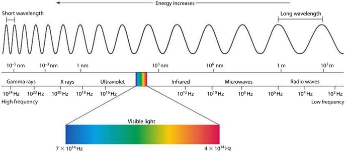
The electromagnetic (EM) spectrum describes the entire range of frequencies of EM radiation that exists. Different portions or classes of the EM spectrum can be broken out according to its frequency or wavelength, including gamma rays (short wavelength, high frequency), visible light (longer wavelength, lower frequency), and radio waves (longest wavelength, lowest frequency). Portions of the electromagnetic spectrum penetrate the atmosphere better than others, allowing earth observation sensors to effectively detect frequencies within the visible, infrared, and microwave spectrum.
Sensors are designed to record EM radiation within discrete ranges, or bands. For example, optical sensors often have bands representing red, green, and blue light. The exact range of wavelengths recorded for each band varies by sensor. For example, Sentinel 2’s red band covers a wavelength range of 650nm to 680nm, while Landsat 8’s red band records data in the range of 635.8nm to 673.35nm. Wavelengths and band lengths are typically expressed in nanometers or micrometers in remote sensing.

The Electromagnetic Spectrum: Remote sensing instruments are designed to capture specific ranges of the electromagnetic spectrum. miniphysics.com
Optical sensors
Optical sensors use optical elements such as lenses and mirrors to capture light.
Light in the visible and infrared ranges can be detected with optical sensing. Land cover is commonly differentiated with information from optical sensors, as various materials on the Earth’s surface reflect energy differently in this range, allowing us to classify land cover and make other inferences about the planet using optical data.
Thermal remote sensors measure radiation being emitted from the earth’s surface or a target body, rather than reflected radiation in the case of optical sensors, as described above. Thermal energy registers in the thermal infrared region of the electromagnetic spectrum and can be used to make temperature measurements of the land or sea surface. Applications include measuring the presence of irrigation leaks in agricultural areas, modeling regional energy balances between land surfaces and water bodies, and fire detection.
Passive sensors
Passive systems, including Landsat and MODIS, measure the amount of electromagnetic energy being reflected or emitted from the Earth using a passive illumination source, such as the sun.
Active sensors
Active sensors, including radar and lidar, do not rely on energy from the Sun or Earth’s thermal properties. Instead, active remote sensing sensors transmit energy toward the Earth’s surface, which then interacts with the terrain and returns back to the sensor. Several active remote sensing platforms use radar to scan the Earth’s surface. Radar has a longer wavelength when compared to visual light, causing it to have atmosphere and cloud-penetrating properties. Thus, radar data can be especially useful for monitoring tropical areas that are covered in clouds much of the year. LiDAR, or light detection and ranging, uses time-of-flight imaging to measure distance to objects. LiDAR operates at a shorter wavelength of laser light, typically at 0.90 𝜇m or 1.50 𝜇m.
You can find synthetic aperture radar data in the Descartes Labs Catalog under the Sentinel 1 product, which transmits long wavelength, C-band microwaves at 5.6 cm.
Platforms
Platforms are the objects that carry sensors. These can be stationary, moving linearly, or orbiting. Many of the datasets hosted by Descartes Labs collect imagery from sensors mounted on satellites in orbit. Others were collected on special missions by attaching sensors to airplanes. Satellite platforms can be in several types of orbits depending on their mission. Most Earth observation satellites are in Sun synchronous, low Earth orbit (Landsat, Sentinel). Sun synchronous orbits allow a satellite to move with the Sun, maintaining a constant illumination angle as it images the Earth.
For satellites that need to maintain a consistent view (weather satellites), a geostationary orbit keeps the sensor over the same location at all times. Geostationary orbits are often used to collect data over large areas of the Earth very frequently. Airborne platforms allow for greater flexibility with regards to how imagery is collected, and can include airplanes, drones, or balloons. Imagery can also be collected using ground-based platforms such as hand-held devices, tripods, towers, or cranes.
