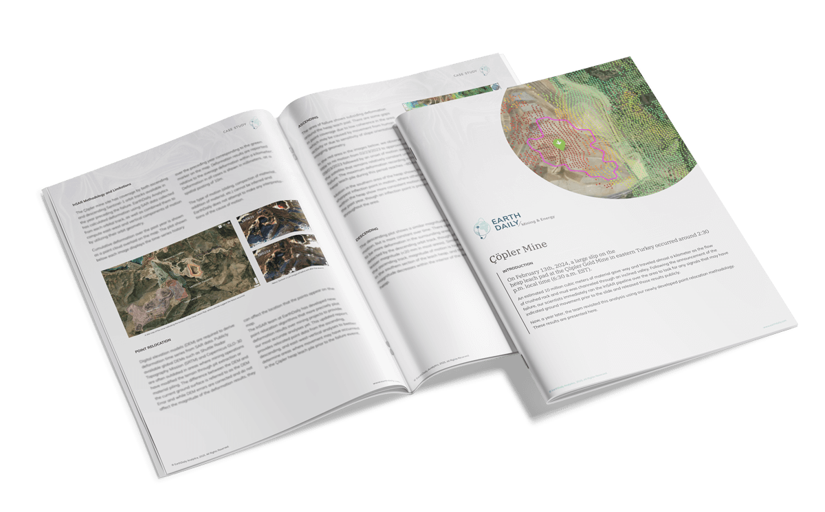
EarthDaily InSAR Monitoring

Precision Infrastructure Monitoring with Advanced InSAR Technology
iris_copler_descending_anomaly

Detect and mitigate ground deformation risks with real-time, high-resolution satellite intelligence.

Accelerate Decision-Making with EarthDaily’s InSAR Monitoring

<18 hours

from data ingestion to analysis delivery

75% cost savings

compared to traditional monitoring programs

Automated alerts

for rapid risk identification

Advanced InSAR-Based Deformation Monitoring

Stay ahead of potential risks with unparalleled infrastructure monitoring. EarthDaily’s InSAR technology delivers precise, high-frequency surface deformation insights to protect critical assets, optimize operations, and mitigate risks.

what-is-marigold_ui

Maximize Efficiency with Hyperspectral Processing

  • Accelerated Deposit Identification: Quickly and accurately locate mineral deposits using unique spectral signatures.
  • Cost Reduction: Improve field planning prioritization, reducing exploration expenses.
  • Enhanced Organizational Growth: Expand mining use cases and foster innovation through shared investments across departments.

Why Choose EarthDaily for Deformation Monitoring?

  • Comprehensive Coverage: Consistently monitor infrastructure across diverse geographies.
  • Proactive Risk Management: Identify anomalies early to prevent costly disruptions.
  • Seamless Integration: User-friendly, no-code interface for simplified monitoring and reporting.
Case Study

Çöpler Mine

This in-depth case study delivers a retroactive look at the Çöpler Mine disaster using remote InSAR monitoring. See how Iris detects movement before failure and helps safeguard future mine sites.

019-3-4-1

Who We Serve

Mining

Ensure operational safety, compliance, and transparency by monitoring infrastructure like tailings dams and open pit walls. Receive real-time alerts on ground movement to prevent disruptions and environmental hazards.

Government & Regulatory Bodies

Improve decision-making with real-time deformation insights. Track industry-related ground movements and infrastructure risks, enabling better regulatory oversight and permitting decisions.

Risk Assessment & Insurance

Support predictive maintenance with early-warning InSAR alerts, mitigating costly claims for insurers, real estate, and civil planning. Quantify ground movement risks to enhance investment confidence and improve safety.

Environmental & Humanitarian Initiatives

Utilize ground deformation data to advocate for responsible resource extraction, enhance disaster response planning, and ensure environmental transparency.


Use Cases: Challenges, Solutions, and Outcomes

Use Case:

Mining Companies

Challenge:
Mining companies face infrastructure instability risks, including tailings dam failures and mine wall collapses, which pose safety hazards and financial liabilities.

Solution:
EarthDaily’s InSAR monitoring provides early warnings of ground movement, enabling proactive maintenance and risk mitigation.

Outcome:
Improved operational safety, reduced regulatory fines, and optimized resource allocation through real-time data insights.
Use Case:

Government Regulatory Bodies

Challenge:
Regulatory agencies need reliable, large-scale data to monitor compliance and assess environmental impact but lack access to continuous, high-resolution monitoring.


Solution:
EarthDaily’s InSAR technology delivers precise, high-frequency surface deformation insights, aiding in informed decision-making and regulatory enforcement.

Outcome:
Enhanced oversight capabilities, improved infrastructure safety, and more effective regulatory compliance enforcement.

Unlock Powerful Insights with EarthDaily’s Advanced Features

EarthDaily-Icons_Calibration

See the Unseen with High-Resolution Monitoring

Detect subtle terrain shifts that traditional sensors miss. InSAR’s precision ensures early identification of deformation risks.

EarthDaily-Icons_Change Detection-06

Enhance Stakeholder Confidence

Demonstrate commitment to safety and sustainability, meeting environmental regulations and improving public perception.

EarthDaily-Icons_Cost Down

Reduce Operational Costs

Lower insurance premiums and minimize downtime with proactive monitoring, reducing maintenance expenses and unexpected failures.

EarthDaily-Icons_Strategy

Streamline Operations & Extend Asset Lifespan

Optimize predictive maintenance efforts and maximize resource extraction with data-driven decision-making.


Product Features

Automated Deformation Alerts

Get notified instantly about ground movement changes to take preemptive action.

On-Demand Historical Analysis

Access years of archived SAR data for a deeper understanding of terrain changes and risk patterns.

Custom Integration & Data Accessibility

Seamlessly integrate InSAR data with GPS, field sensors, and other monitoring tools.

Protect your assets and mitigate risks with the most advanced InSAR monitoring technology available.

Request a Demo